links for 2010-03-03
-
Public universal health care around the world (as of December 2009).
The Mother Road: Historic Route 66 – a great information website has “Turn by Turn” maps that identify where Route 66 is, since some of the original road is no longer, and most of it isn’t marked with highway markers anymore.
Turn by Turn Route 66 in Google Maps – Some kind Google Earth enthusiast has taken the maps from the site above and plotted them out using Google Earth/Maps. Awesome!
Photographic Interests in Illinois along Route 66 – Someone else marked famous landmarks in Illinois via Google Earth. Nice, handy.
However, if you just want to follow along with the song – there’s a google earth map for that, too.
Twittervision is a googlemap with all the latest twitter posts displayed on it – it’s pretty mesmerizing to watch – check it out.

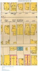
Sanborn maps were fire insurance maps that showed neighborhoods and houses for the purposes of determining insurance rates. This is the 1898 map of my neighborhood, showing my house as it looked at that time. I used to have a wrap-around front porch. There also appears to have been a stable on the property.
See the picture on Flickr.